DMZ travel guide
DMZ Overview
In 1954, Ho Chi Minh’s government in the north and the French colonial administration in the south agreed an armistice that involved a ‘temporary’ partition of Vietnam. The Ben Hai River, in the extreme north of
Quang Tri province, became the arbitrary line dividing the two halves of the country. When the southern ‘government’, backed by the US, reneged on the national elections promised in the agreement, Quang Tri became the theatre where most of the important scenes of the
Vietnam War were staged.
The
DMZ extends 5 km north and south of the
Ben Hai River and runs approximately 100 km from the South China Sea to the Laos border. Originally proposed as a temporary demarcation line between the communist controlled north and the “democratic” south, the DMZ became the permanent border between
North Vietnam and
South Vietnam when the 1956 nationwide elections were cancelled due to the obvious imminent victory of Ho Chi Minh and the Communists. Fearing the downfall of the South Vietnamese government to the powerful Communist Army of the North, the United States began sending military advisors, troops, supplies and weapons to the South Vietnamese government headed by president Ngo Dinh Diem. In an effort to supply the Viet Cong (South Vietnamese Communists) with troops and armaments, the North Vietnamese Army (NVA) created a series of interconnecting roads and trails (approximately 20,000 km in total) popularly known as the Ho Chi Minh Trail, which extended from North Vietnam to the South.
In an attempt to stop this flow of munitions, the United States and the Army of the Republic of Vietnam (ARVN, the South Vietnamese Army) created a series of bases along Route 9 (which parallels the DMZ approximately 10 km to the south). This series of bases, mines and electrified fencing became known as the McNamara Line, named for the U.S. Secretary of Defense, Robert McNamara. Some of the fiercest and bloodiest battles of the American War in Vietnam occurred along this line at places such as Khe Sanh Combat Base, The Rockpile, Camp Carroll, Con Thien Firebase and Doc Mieu Base. We spent our first day in Vietnam visiting the remains of these and other sites along the DMZ. It was an educational and sobering experience best summed up by our Vietnamese guide, “A war with no winners.”
In an attempt to stop this flow of munitions, the United States and the Army of the Republic of Vietnam (ARVN, the South Vietnamese Army) created a series of bases along Route 9 (which parallels the DMZ approximately 10 km to the south). This series of bases, mines and electrified fencing became known as the McNamara Line, named for the U.S. Secretary of Defense, Robert McNamara. Some of the fiercest and bloodiest battles of the American War in Vietnam occurred along this line at places such as Khe Sanh Combat Base, The Rockpile, Camp Carroll, Con Thien Firebase and Doc Mieu Base. We spent our first day in Vietnam visiting the remains of these and other sites along the DMZ. It was an educational and sobering experience best summed up by our Vietnamese guide, “A war with no winners.”
Destinations
Vinh Moc Tunnel
In June 1965, Vinh Moc was almost entirely destroyed. The people of Vinh Moc started digging an underground network of tunnels and rooms for the village popunLtion, comprising 82 families for total of 300 people. The passage is approximately 7m under the surface. Seventeen babies were delivered in the passage during the war.
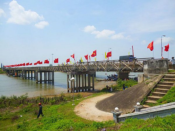
The 17th Parallel (Ben Hai Rriver and Hien Luong Bridge)
Ben Hai River runs 100km in Truong Son Mountains to meet the sea at
Cua Tung Mouth. The widest part of the river is about 200m, the portion covered by Hien Luong Bridge is approximatele 170m wide. Under the Geneva agreement on Vietnam in 1954, Ben Hai River was selected as a temporary demarcation line separatingthe country into two parts,.Hien Luong Bridge was divided into parts, each serving as a border gate. Nowadays, Ben Hai River and Hien Luong Bridge have become the historic landmarks and
great tourist attractions.
Quang Tri Citadel was built in 1824 upon order of Minh Mang King. The citadel was initially built in clay and was rebuilt with bricks four years later. Nowadays, you can see several pieces of brick walls remaining from the citadel.
Khe Sanh Conbat Base
Khe Sanh is a valley surrounded entirely by rolling mountains and forest. Topographically, Khe Sanh is similar to
Dien Bien Phu. It used to be an American defense station believed to be unassailable. The entrenched fortifications surrounding Khe Sanh comprise three areas: Ta Con, Lang Vay and Huong Hoa. More than 10,000 army men were stationed at
Khe Sanh, not to speak of many other troops ready to intervene.
Truong Son National Cemetery
Truong Son National Cemetery is a sobering memorial to the tens of thousands of North Vietnamese soldiers who were killed in the Truong Son Mountain Range along the
Ho Chi Minh Trail. Row after row of white tombstones stretch across the hillsides. The cemetery is maintained by disabled war veterans. The soldiers are buried in five zones according to the part of Vietnam they came from, and each zone is further subdivided into provinces. The gravestones of five colonels and seven decorated heroes, including one woman, are in a separate area. Each headstone bears the inscription ‘Liet Si’, which means martyr. The remains of soldiers interred here were originally buried near the spot where they were killed and were brought here after reunification.
Many graves are empty, simply bearing the names of a small number of Vietnam’s 300,000 MIAs. The site where the cemetery now stands was used as a base by the May 1959 Army Corps from 1972 to 1975. Named after the date on which they were founded, they had the mission of constructing and maintaining a supply line to the South – the legendary Ho Chi Minh Trail. On the hilltop above the sculpture garden is a three-sided stele with inscriptions paying tribute to this corps and outlining their history. The road to Truong Son National Cemetery intersects Hwy 1A 13km north of Dong Ha and 9km south of the Ben Hai River; the distance from the highway to the cemetery is 17km. A rocky path that is passable by motorbike links Cam Lo (on Hwy 9) with Truong Son National Cemetery (18km). This track passes rubber plantations and also the homes of Bru (Van Kieu) people, who cultivate, among many other crops, black pepper.
Many graves are empty, simply bearing the names of a small number of Vietnam’s 300,000 MIAs. The site where the cemetery now stands was used as a base by the May 1959 Army Corps from 1972 to 1975. Named after the date on which they were founded, they had the mission of constructing and maintaining a supply line to the South – the legendary Ho Chi Minh Trail. On the hilltop above the sculpture garden is a three-sided stele with inscriptions paying tribute to this corps and outlining their history. The road to Truong Son National Cemetery intersects Hwy 1A 13km north of Dong Ha and 9km south of the Ben Hai River; the distance from the highway to the cemetery is 17km. A rocky path that is passable by motorbike links Cam Lo (on Hwy 9) with Truong Son National Cemetery (18km). This track passes rubber plantations and also the homes of Bru (Van Kieu) people, who cultivate, among many other crops, black pepper.
